
A guidebook is a very important aid for engaging in mountaineering. It can be ignored only by total adventurers who crave surprise, don’t wish to know anything about who climbed before them, and where, but who wish to approach the ascent as if they were the first. Of course, all other mountaineers operate differently. First ascents are recorded, first into a summit book, later in some cabin or similar base (in rocky regions it is usually the nearest pub); this information is gathered until some careful and sufficiently assertive individual arranges everything into a form suitable for publication as a book. And then the public receives a mountaineering guidebook. Its primary purpose is to disseminate information in order that people may know the ascent routes on the mountain or rock, where they lead, how difficult they are, how long the ascent takes, and last but not least in the case of mountain terrain, how to get down from the summit. An associated objective of the mountaineering guidebooks is their archival and historical role, as the information about who performed the first ascent and when is recorded through it.
From the above we can see what such a properly produced guidebook should include in order to fulfil all of these purposes. First and foremost, without which such a work could not even be called a mountaineering guide, is the following:
- a list of routes
- textual or graphical description of routes
- a level of complexity indicated for each route
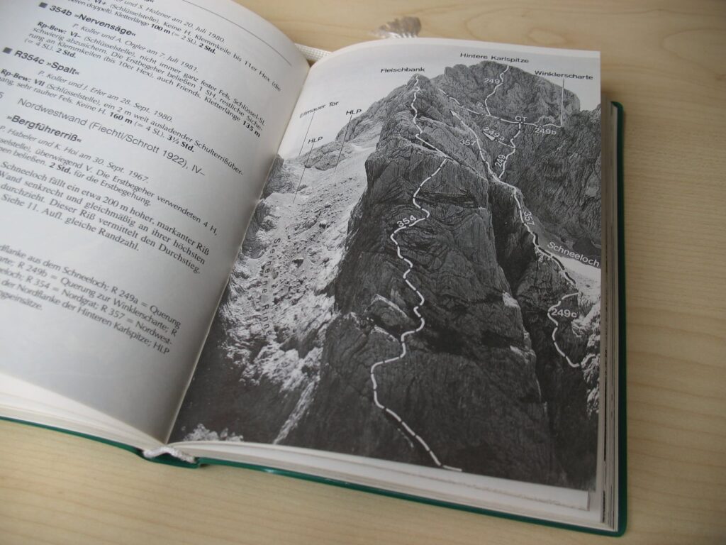
And yet it is a tried and tested reality that a mountaineering guidebook offers far more, especially in more extensive rocky regions we would never get by with such brief contents. And for mountain climbing the thoroughness of a guidebook is even more important. For this reason guidebooks usually also contain maps, photos or sketches of rocks or mountain faces in which the trajectories of ascent routes are diagrammed, more complex ascents have not infrequently specially executed diagrams using topographical symbols where the individual pitches are drawn out, the key spots on the ascent are marked, etc. Maps are phased according to several different indices, as a rule there is one universal map in the guidebook, and according to the complexity of the region then a series of more detailed maps. In the case of rocks and rock towns, the layout of the individual rock structures are drawn with arrows designating the approaches to the routes. A good habit is to add a designation of the directional faces in order that we can later manage to properly orient the map in the terrain. When describing the ascent routes, common terminology is used as we have established it in previous sections of the book. A description of the route as a rule begins with the name of the route, and then usually the first ascensionists and the date of first ascent are listed. The names of the first ascensionists in particular can offer important associated information. The first ascensionist, or the author of the route, can in some cases be a person of a distinctive character, which is expressed in his/her work (the route, and above all the fixed protection in it) . In some cases the authorship of the route “warns” us what it will contain. There were and are first ascensionists who accomplished nice routes, but sometimes there are also those who as a result of their particular machismo left behind them routes whose repetition is a terrifying challenge. Subsequently in the appropriate paragraph on the route there is usually a description of how the route passes through the terrain. At the end of this description the complexity rating of certain rating systems is listed.
Continued in the book >>
| iPhone, iPad, Mac | |
| Android, web browser | |
| Kindle Fire |  |
| Kindle e-ink | |